Bowker Creek Blueprint Update

A 100-Year Action Plan to Restore the Bowker Creek Watershed
The Bowker Creek Initiative (BCI) was established in 2004 as a coalition of community, local government, and institutions working collaboratively to protect and enhance the ecological, social and economic health of the Bowker Creek watershed.
In 2011, the Bowker Creek Blueprint was created as a detailed 100-year action plan to revitalize the Bowker Creek watershed. The Blueprint identified a series of actions that would lead to improvements in the watershed and to the creek, habitat and community.
It is now time to update the Blueprint and revise actions based on accomplishments, new information and current pressures facing the watershed. The updated Blueprint will continue to guide the municipalities, the community, and other land stewards to manage and restore the watershed and creek corridor into the future.
Thank you for your participation.
Thank you for sharing your feedback on the Bowker Creek Blueprint Update. A What We Heard Report has been completed. The updated Blueprint is expected to be available summer 2026.
-
About the Bowker Creek Watershed
Share About the Bowker Creek Watershed on Facebook Share About the Bowker Creek Watershed on X (formerly Twitter) Share About the Bowker Creek Watershed on Linkedin Email About the Bowker Creek Watershed link Bowker Creek runs from the University of Victoria campus, through Saanich and Victoria and into the ocean at Oak Bay.
In the past, Bowker Creek was a natural, winding stream with small tributaries and wetlands. It was home to fish like cutthroat trout and salmon. However, as the area developed, much of the creek was buried in pipes, and its natural landscape was changed.
Today, Bowker Creek is highly urbanized which has led to problems like flooding and poor water quality. A majority of the creek has been enclosed in pipes and almost half of the watershed is covered by hard impervious surfaces, like roads and roofs, which prevents rainwater from soaking into the ground and instead directs polluted water into the creek.
Did you know?
A watershed is the area of land that drains surface water and groundwater to a common water body, such as a creek, stream, lake or the ocean. We all live in a watershed, regardless of how far we are from a body of water; therefore, the activities we do on land impact our water quality.
• 45% of the Bowker Creek Watershed is impervious and can’t absorb rainfall
• 66% of Bowker Creek has been enclosed in pipes
• 69% of the Bowker Creek Watershed doesn’t have tree cover
-
Vision & Goals of the Bowker Creek Blueprint
Share Vision & Goals of the Bowker Creek Blueprint on Facebook Share Vision & Goals of the Bowker Creek Blueprint on X (formerly Twitter) Share Vision & Goals of the Bowker Creek Blueprint on Linkedin Email Vision & Goals of the Bowker Creek Blueprint linkAs we update the Blueprint the following goals will be achieved through a series of watershed wide actions and creek corridor actions with the ultimate goal of achieving the vision.

Vision of a healthy Bowker Creek that provides habitat, supports biodiversity, helps manage flooding and is a community amenity. Image courtesy of MDI Landscape Architects.
Vision
The varied human uses and natural areas in the Bowker Creek watershed are managed to minimize runoff and pollution, making Bowker Creek a healthy creek that supports habitat for native vegetation and wildlife, and provides a community greenway to connect neighbourhoods.
Goals
 Nature and Biodiversity: Improve and expand public areas, natural areas, and biodiversity in the watershed
 Water Quality: Achieve and maintain acceptable water quality in the watershed
 Manage Flow: Manage flows effectively
 Take Action: Individuals, community and special interest groups, institutions, governments, and businesses take responsibility for actions that affect the watershed
 -
Benefits of a healthy urban watershed
Share Benefits of a healthy urban watershed on Facebook Share Benefits of a healthy urban watershed on X (formerly Twitter) Share Benefits of a healthy urban watershed on Linkedin Email Benefits of a healthy urban watershed linkThere are many benefits of a healthy urban watershed including increased resilience to our changing climate, clean water, biodiversity and improved livability for all.
Watershed Infographic (click to view full size infographic)

-
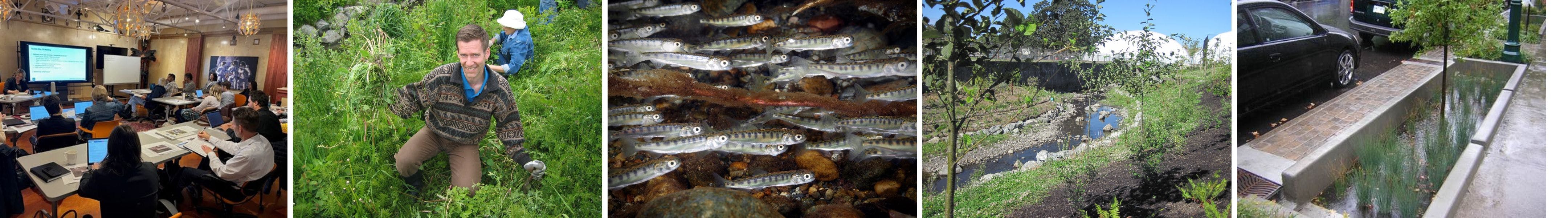
Key Accomplishments
Share Key Accomplishments on Facebook Share Key Accomplishments on X (formerly Twitter) Share Key Accomplishments on Linkedin Email Key Accomplishments linkConsiderable progress has been achieved since the development of the Bowker Creek Blueprint. A few examples are shared below and view more in the Bowker Creek 10 year Achievements:
Oak Bay High School Restoration


The restoration of Bowker Creek through Oak Bay High School lands in 2015, transformed this section of the creek to include a meandering channel with riffles, small islands, a healthier riparian environment, an accessible community greenspace, outdoor classroom and public walkway. This was a successful partnership between School District 61, Oak Bay Secondary School, the District of Oak Bay and the Bowker Creek Initiative.

Daylighting Feasibility Study


The Daylighting Feasibility Study identified opportunities to open the creek channel and release Bowker Creek from underground pipes. It also identified locations for potential stormwater management facilities that can reduce flooding. This work is a critical milestone in the efforts of local governments and community groups to improve the health of the Bowker Creek watershed. Municipalities are now able to integrate creek daylighting options into redevelopment plans.

Demonstration Rain Garden Projects


Rainwater management demonstration sites have been established in several locations throughout the watershed. Rain gardens help protect water quality and reduce flooding in Bowker Creek by slowing and retaining rainfall and filtering pollutants. Look for them on McKenzie Ave in the District of Saanich, at the Monterey Recreation Centre in Oak Bay and at Hillside Centre in Victoria.

Kings Road Community Nature Green Space


In 2019 the District of Saanich purchased the former BC Hydro lands near the Royal Jubilee Hospital to create a new park currently known as the King’s Road Community Nature Green Space. Community fundraising efforts and financial help from other agencies including the City of Victoria and the District of Oak Bay contributed to its purchase. King’s Road Community Nature Green Space is a key property in the Bowker Creek Watershed with open space and opportunities for restoring Bowker Creek to be ecologically robust and resilient for generations to come, improve stormwater management and mitigate flooding.

Community Spotlight The Friends of Bowker Creek Chum Salmon Recovery Project
The Friends of Bowker Creek (FoBC) is a community based group that works to “support the restoration and enhancement of Bowker Creek and its watershed to a healthy state, guided by the vision and goals of the Bowker Creek Blueprint.” The FoBC have been instrumental in organizing educational and stewardship work that make an important on-the-ground difference in the watershed. In 2020, FoBC lunched the Bowker Creek Chum Salmon Recovery Project, a multi-year project with the aim of restoring chum salmon back to the lower reaches of Bowker Creek. Volunteer stream keepers are measuring water and habitat quality, and releasing chum salmon into the creek over the next few years.

-
Goals and Approaches
Share Goals and Approaches on Facebook Share Goals and Approaches on X (formerly Twitter) Share Goals and Approaches on Linkedin Email Goals and Approaches linkThe following approaches are being integrated into the updated actions to achieve the four goals of the Bowker Creek Blueprint.
 Goal 1: Improve and expand public areas, natural areas and biodiversity in the watershed.
Approach 1: Plant native trees and plants & remove invasive species
Native trees and plants are vital components of healthy and resilient ecosystems. They provide ecosystems services such as food and habitat for native wildlife, absorption of rainfall, shading cooling and resilience to climate change. Urban development and invasive species have reduced available habitat for native plants. By continuing to remove invasive species and planting native species we can support biodiversity in the watershed.
Approach 2: Creek restoration
Creek restoration involves working towards the recovery and renewal of a degraded creek. Restoration of sites along Bowker Creek can include: rehabilitation of riparian areas with native plants and trees, removal of invasive species, creation of more gently sloping banks where appropriate and other activities that help improve habitat and water quality. The restored creek will provide a community amenity and gathering space as well as ongoing education on the many benefits of a healthy watershed.
Approach 3: Create biodiverse corridors through greenways
A multi-use greenway corridor from the headwaters to the ocean will provide habitat connectivity through the watershed, improve biodiversity, and provide routes and connections to regional trails improving safe walking, cycling and nature viewing throughout the watershed.

 Goal 2: Achieve and maintain acceptable water quality in the watershed
Pollution is often caused by curbside storm drains which take stormwater directly to Bowker Creek. The surfaces of roadways and parking lots are contaminated with oil and other chemicals from cars, and this pollution is quickly delivered to the creek when it rains, causing serious pollution problems.
Approach 1: Green Stormwater Infrastructure
As rain travels over roofs, driveways and roads it picks up chemicals, metals, dirt and oils. Green stormwater infrastructure can improve water quality and can clean and infiltrate rainwater runoff before reaching the natural receiving environment. A raingarden can absorb runoff and reduce these contaminants through soil filtration and vegetative uptake. Incorporating this infrastructure throughout the watershed will help improve water quality and fish habitat.
Approach 2: Preventing Pollution
Homeowners and developers can prevent pollution in many ways including minimizing hardscape areas for driveways and patios and avoiding the use of chemicals where possible. Preventing contaminants and sediment from entering storm drains and Bowker Creek can make significant improvements to watershed health.
What can you do? Watch our Prevent Pollution video
Approach 3: Monitoring Water Quality
Continuing water quality monitoring will provide information about the health of the creek and where to focus our efforts. The CRD and the Friends of Bowker Creek conduct water quality monitoring in Bowker Creek. Recent data indicates that inputs and urban development in the watershed continue to degrade water quality. Many water quality parameters have at times been measured at levels that can be harmful to aquatic life.

 Goal 3: Manage flows effectively
Historically the Bowker Creek Watershed has had issues with flooding of public and private property. Urban redevelopment generally results in an increase in impervious area (i.e. roads, sidewalks and buildings), which increases peak flows and volumes. Furthermore, climate change predictions indicate more intense rainfall in the winter.
Approach 1: Green stormwater infrastructure
Rain gardens, green roofs, bioswales, tree soil cells, permeable pavers, cisterns and infiltration chambers are all examples of green stormwater infrastructure that capture and slow the flow of rainfall and allow it to infiltrate the ground like it would in the natural environment. There are many examples of this in the Bowker Creek watershed and more are needed to minimize peak flows and prevent flooding.
Approach 2: Daylighting
Freeing the creek from underground pipes can provide increased capacity in the creek to help manage flows; provide habitat in support of protecting and restoring biodiversity (including efforts to reintroduce chum salmon); and provide a valued community amenity.
A Daylighting Feasibility Study provided options for removing piped sections of Bowker Creek and restoring it to an open channel along the entire length of the creek. A restored Bowker Creek will provide stormwater benefits as well as numerous aesthetic, economic, and environmental benefits.
Approach 3: Large stormwater storage facilities
Opportunities for large stormwater management facilities are being explored through land owner partnerships as a mechanism to help manage flows and restore hydrological function to the watershed. Examples can include playing fields that can be designed to store rainfall from large storm events for a 24 hour period.

 Goal 4: Individuals, community and special interest groups, institutions, governments, and businesses take responsibility for actions that affect the watershed
Approach 1: Incorporate Blueprint goals and actions into municipal plans
All three municipalities have successfully incorporated Blueprint goals and actions into municipal plans. Most recently the City of Victoria and District of Saanich included Bowker Creek in their Official Community Plan (OCP) engagements. This approach continues to be important as Official Community Plans (OCP) are updated, and other action plans or strategies are developed.
Approach 2: Education and engagement
Providing educational information and engaging with the residential, institutional and business community helps to foster landowner and community awareness and connection to Bowker Creek, builds a culture of stewardship and encourages action. Approximately 30,000 people live in this watershed. It will take actions by everyone to restore a healthy creek.
What can you do? learn more about Bowker Creek stewardship
Approach 3: Collaboration and partnership
Building relationships with landowners, community groups, schools, public organizations, First Nations and municipal governments is an important way to move the Blueprint forward. In a highly urban environment, voluntary partnerships in pursuit of achieving the Blueprint goals are needed to restore Bowker Creek to a healthy watershed.

-
The Bowker Creek Blueprint Update
Share The Bowker Creek Blueprint Update on Facebook Share The Bowker Creek Blueprint Update on X (formerly Twitter) Share The Bowker Creek Blueprint Update on Linkedin Email The Bowker Creek Blueprint Update linkThe Bowker Creek Blueprint Update includes actions for municipalities, community groups, institutional partners and landowners to implement and achieve the vision for Bowker Creek over 100 years.
Watershed Wide actions refer to those actions that should be implemented across the entire watershed.
Creek Corridor Actions are specific to the creek channel.


The 2025 Updates include:
Watershed Wide Actions
- 42 updated actions
- 10 key actions for short term implementation (within 10 years)
Creek Corridor Actions
- 108 updated actions in 17 creek sections
- 11 key actions for short term implementation (within 10 years)
-
Watershed Wide Short Term Actions
Share Watershed Wide Short Term Actions on Facebook Share Watershed Wide Short Term Actions on X (formerly Twitter) Share Watershed Wide Short Term Actions on Linkedin Email Watershed Wide Short Term Actions linkWatershed Wide actions are those that apply across the watershed and not to a specific area of the creek. These short-term actions have been identified as a priority in the next 10 years.
 1. Integrate Blueprint 2.0 goals and actions into municipal plans, strategies and projects as they come up for review or update using common language.
 2. Identify Bowker Creek in natural asset inventories and explore options for its protection such as the development of natural asset management plans.
 3. Complete an archaeological overview assessment of the entire Bowker Creek system in partnership with involved First Nations.
 4. Implement a communication and engagement strategy to foster a culture of watershed stewardship and pollution prevention.
 5. Develop and implement a Strategic Land Acquisition Plan that identifies a short-list of properties for acquisition to facilitate restoring and daylighting Bowker Creek which prioritizes flood-vulnerable properties and consider incorporating properties into municipal land acquisition strategies.
 6. Explore daylighting design guidelines including typical cross-sections to achieve a consistent appearance (i.e., landscaping, and signage) for a variety of urban conditions and constrains.
 7. Update stormwater modelling with updated climate change predictions to support climate resiliency and flood prevention.
 8. Maintain flow monitoring stations and data collection to inform the stormwater master plan.
 9. Explore invasive species prevention and management strategies that include target dates/budgets/plans for annual surveys and removal activities and embed these into municipal operational plans and budgets. Provide staff training to identify and map priority invasive species in the watershed, and to watch for and report new arrivals.
 10. Review and update short-term actions in ten years.
For more watershed wide action view the Watershed Wide Action Table
-
Creek Corridor Actions
Share Creek Corridor Actions on Facebook Share Creek Corridor Actions on X (formerly Twitter) Share Creek Corridor Actions on Linkedin Email Creek Corridor Actions linkCreek corridor actions are those that apply to a specific area of the creek. These short-term actions have been identified as a priority in the next 10 years.
Creek Corridor Actions Map (click to view full size map)

For more creek corridor actions view the Creek Corridor Actions Table
Documents
-
 What We Heard Report - Bowker Creek Blueprint (3.6 MB) (pdf)
-
2011 Bowker Creek Blueprint.pdf
-
Landsdowne Campus Map.pdf (847 KB) (pdf)
-
Creek Corridor Actions Map.pdf (9.1 MB) (pdf)
-
Watershed Wide Actions by Goal Area (Draft).pdf (144 KB) (pdf)
-
Short Term Actions (Draft).pdf (135 KB) (pdf)
-
Bowker Creek Infographic.pdf (2.03 MB) (png)
-
Creek Corridor Actions (Draft).pdf (9.65 MB) (pdf)
-
Open House Display Boards (17.9 MB) (pdf)
-
Virtual Information Session Recording 12 June 2025 (151 MB) (mp4)
-
Virtual Information Session Powerpoint Slides 12 June 2025 (24.9 MB) (pdf)
